
Halifax's Third Crossing
What the JRTA report should say

A few years ago, the province struck up the Joint Regional Transportation Agency (JRTA), with a mandate to study and suggest regional transportation improvements. It partnered with a couple of well-known engineering firms to build a travel demand model and provide some insights. Now, due to my day job, I have some experience with what you get when you hand these firms a cheque and ask for a model and analysis.
First and foremost, there’s the months of waiting. By far, the most time will be spent calibrating the base year, which is just trying to explain what’s happening today. Then you’ll usually get a cool-looking map of the road network like this (yellow-red being bad — roads at capacity).
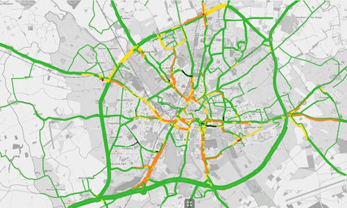
Forecasting is secondary, but the modeler will pick a year — say 2045 — and try to solve the model again (having inflated volumes based on population forecasts and such). The map likely shows many more roads being red, not good.
This can easily become a fun-house mirror: the JRTA wants a model to probe future possibilities, but those future possibilities are inherently anchored by inputs (like population forecasts) that the JRTA is meant to be affecting1.
Not only that, but traffic models are extremely cumbersome — hence the months for any “answers” — and don’t show great forecasting ability either. They are trying to simulate so much about human behaviour, everywhere, all at once.
But since it’s human behaviour, any analysis ought to make just as much sense to you as it does to the traffic engineer. That’s why I think we can skip the million-dollar cheque and the model and just make a nice map. If it makes sense on a map it’s at least got a chance to make sense in real life.
I’m going to ignore the regional part, and focus on the issue people care most about: how to keep Halifax moving.
Third crossing: under sea and through the cut
Halifax’s big picture context is that there are no high-capacity roads on the peninsula. That makes for a great downtown and waterfront, but it leaves several highways dumping onto 1940s-era streets. Bad.
That’s also a challenge for the logical third crossing (a tunnel from the 111 by Woodside on the Dartmouth side). It would be another case of highway-level traffic dumping cars, this time into downtown and the South End.
There’s no land available that can be used to build bigger roads. Even just widening Robie in a few spots is getting backlash
There is just one under-used right-of-way. The rail cut. It currently serves as CN’s freight access to the South End container terminal.
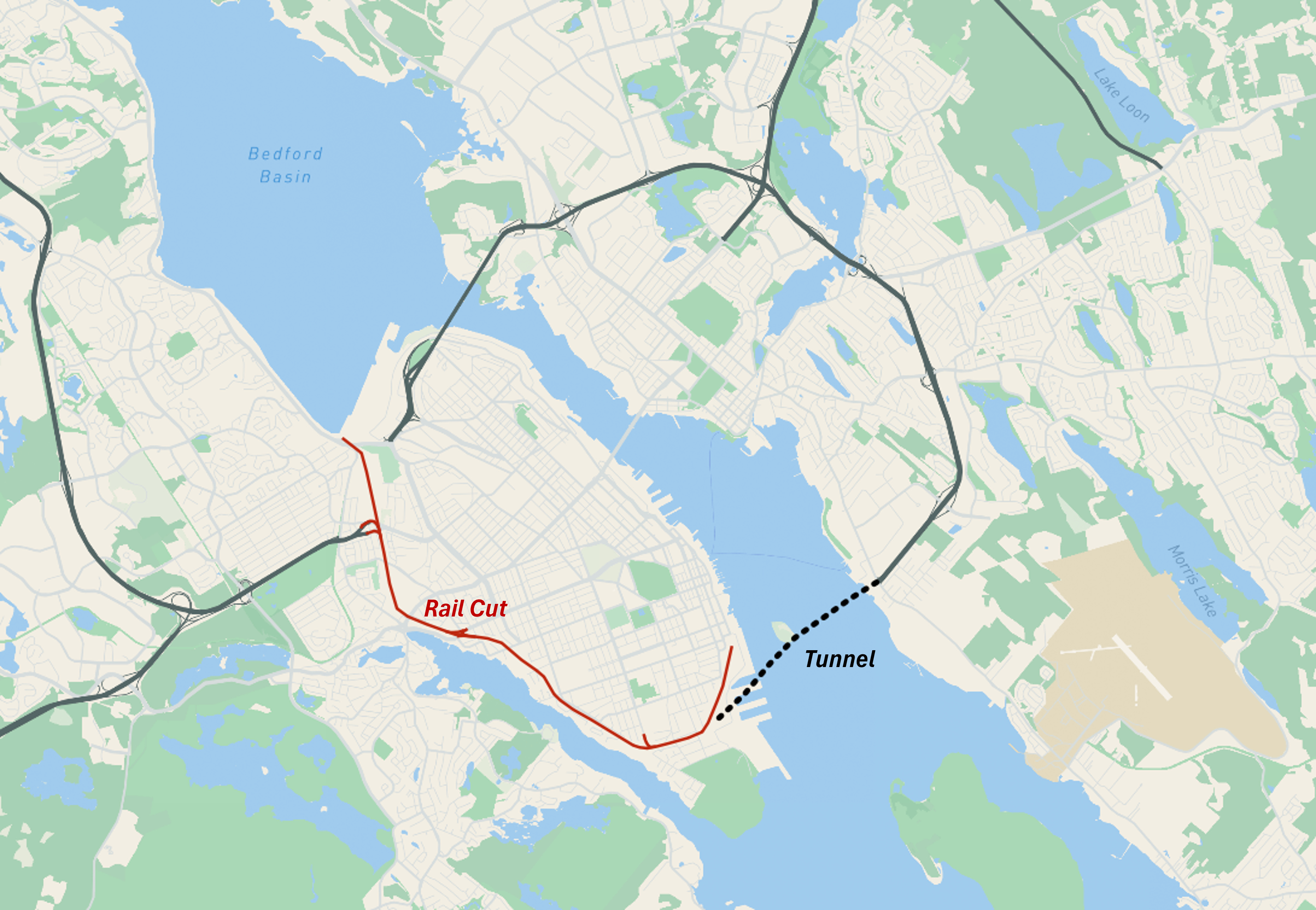
On the map, you can see if you repurposed the rail cut, you could (in theory) connect to the 102 on the edge of the peninsula, down through the South End and into the tunnel across. That completes a ring road — which cities ranging from London to Houston rely on to move vehicles around efficiently.
I think this would genuinely take pressure off Halifax’s peninsular streets, especially by giving suburban residents (think Spryfield) another way to get past the peninsula, and possibly easier access to the MacKay. Basically, on top of another crossing, you add a way of getting to those crossings — which is key for bridge closures (which will also become a larger story as the MacKay approaches its useful life).
Now the caveats. First, this idea basically requires the South End container port to move. Maybe not for the tunnel, but losing the rail cut makes the container port unviable. Politically, that’s challenging. Port jobs are good jobs, with strong unions and sympathy from the public2.
Also, I’ve ignored all of the actual engineering you’d want to do to find out how much road you can fit. A few lanes would likely fit, but the real challenge would be the exits and entries. Ramps take up space (not to mention the elevation differences). But again — traffic is the problem to solve, and there are no good solutions, so I think it’s worth studying beyond my casual map-making.
e.g., Building a new highway can enable a new suburb
The reality is that Halifax’s container port operations are stagnant, and have been for decades, and it’s worth debating whether such useful land is worth keeping as an underperforming port
2+) The port facilities can all be relocated to Fairview with infilling (we need places to dump excavation material) along Fairview Cove up towards MSVU. The rail marshalling yard is there already. Via and potential lrt is another issue: perhaps a passenger line, maybe elevated so it could serve stops along the route, could be worked into a redevelop cut
Fun thought experiment!